Property & Piers

Piers
Before you put in a pier…
consult the WI DNR Pier Planner AND
adhere to Town of East Troy Ordinances: REGULATION OF MOORINGS AND PIERS and
consult Walworth County for applicable ordinances.
Partial Excerpt from the Town of East Troy Ordinances (emphasis added):
16.10.040 Permit.
A permit shall be required for each property having a pier, mooring, navigational or mooring buoy, marina, temporary rigging, or other structure or device that is placed wholly or in part in navigable waters. (2008 code § 12.02(4))
16.10.050 Regulations.
All permits for moorings, piers, wharfs and other structures shall be subject to the following regulations. For the purposes of this section all of the foregoing requiring a permit shall be referred to as a “mooring.” Elsewhere in this chapter, unless such structural devices are specifically named, “mooring” shall presumptively refer to all structures, devices or any other matter requiring a permit under this chapter.
1. No mooring shall materially obstruct navigation.
2. The establishment of a mooring shall not be detrimental to any significant fish or wildlife habitat area or sensitive environmental area. The Town shall consider any application dealing with such issue with the intent of minimizing or avoiding any detrimental impact. Pursuant to 2011 Wisconsin Act 167, a DNR permit is required for every new pier on “designated waters” or “areas of special resource interests” after August 2012 if the pier does not meet the Pier planner [PDF], and the Piers exemption checklist [PDF]. Portions of Lake Beulah are included within both definitions. As such, the Town Board will only grant a permit application for a new pier on waters fitting either or both definitions after approval has been granted by the DNR, or a letter from the DNR confirming that a pier is exempt is provided. A list of “designated waters” or “areas of special resource interest” can be found at http://dnrmaps.wi.gov/H5/?Viewer=SWDV (Surface Water Data Viewer).
From the Pier Planner:
Responsible Parties
“Friends, neighbors or a contractor may assist with installation and maintenance, but owners are responsible for following requirements, obtaining any necessary permits, and for maintenance after construction.”
Placement of Piers
http://dnr.wi.gov/topic/wetlands/locating.html Part 1 of 4 "Waking Up To Wetlands"
Impacting the environment:
“Pier or wharf placement and use may not harm the public interests in waterways, which includes fish and wildlife habitat (such as spawning areas, important vegetation, waterfowl nesting areas); water quality; natural scenic beauty; or public recreation and navigation.”
What’s a wetland?
“Wetlands are not always obvious. Wisconsin has more than a dozen different types and some may be dry for most or all of the year. But all wetlands are protected by law and permits are required before you build on wetlands or otherwise affect them.” - WI DNR https://dnr.wi.gov/topic/wetlands/locating.html
Have a wetland? Explore your options (source: WI DNR)
If wetlands are present on a property, there are options available to you:
Enjoy and explore your wetlands and avoid building on them or otherwise disturbing them. Learn about the important functions and values they provide.
Restore degraded wetlands or enhance them.
If wetlands can’t be avoided, read about the necessary permitting and environmental review process. State and federal (and sometimes local) permits are required for activities that will have an impact on wetlands.
Critical Habitat Areas
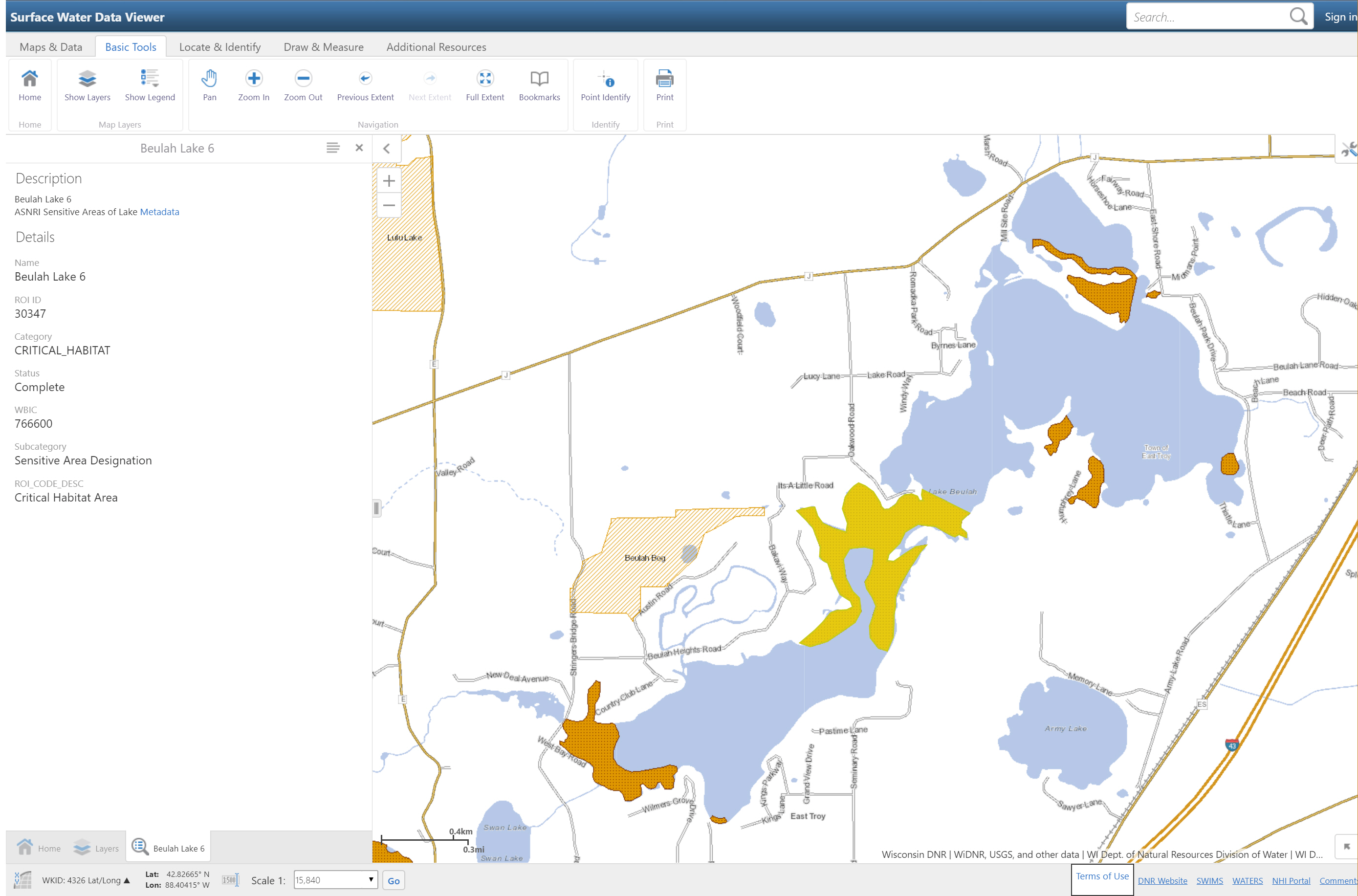
Click image for larger view.
This map shows areas marked (orange or yellow markings on the lake) noted as “Areas of Special Natural Resources Interest (ASNRI)” - Critical Habitat Area - Sensitive Area Designation. While these are not the only areas of sensitive habitat, these are marked the most critical areas of Lake Beulah according to the WI DNR.
To access this interactive map from the WI DNR, go here https://dnr.wi.gov/topic/surfacewater/swdv/ - click “Launch” - zoom in to the lake - under “Basic Tools” click “Show Layers” - then click the checkbox for the “Priority Navigable Waterways” layer.
Obstructing navigation:
“A pier or wharf may not obstruct navigation. In narrow rivers or channels, construct a wharf parallel to the shoreline rather than extending a pier perpendicular to it.”
Boundaries:
“Piers, wharves and moored boats must be placed in the “exclusive riparian zone”, which is the space in the water adjacent to the riparian property where the riparian has the exclusive right to place structures.”
Number of watercraft
“The number of boat slips – the total of all watercraft docked at a pier or wharf including boats in a boat lift or hoist - is limited to 2 boats slips for the first 50 feet of the riparian owner’s shoreline frontage and no more than 1 boat slip for each additional full 50 feet of shoreline. In addition to the boat slip allowance listed here, a riparian owner can secure up to 2 personal watercraft for the first 50 feet of the riparian owner’s shoreline frontage and one additional personal watercraft for each additional full 50 feet of shoreline.”
Shoreland Zoning
Government Resources
To find the latest information regarding your lake property, pier ordinances, permits, etc. visit the following websites:
